About
The Watering Place is a location with a very long and rich American history. The name – Watering Place – was given by early colonial navigators and Dutch merchants to the place on Staten Island where a stream flowed down from the inland hills and emptied into the New York harbor. Here ships anchored to replenish their water supplies. Prior to the first European explorers the Munsee-speaking Indians frequented this place. In their later interactions with the European settlers they referred to themselves as the Delaware Indians and today they are more commonly known as the Lenape Indians. Names often do change over the course of time. Today the Watering Place is known as the Tompkinsville and St. George area of Staten Island.
The Watering Place is arguably one of the most historic places on Staten Island. Many things happened here. The Watering Place was once a British camp during the French and Indian war and again during the Revolutionary war. But perhaps the most notable historic event that took place here was the operation, for six decades (1799 – 1858), of a Quarantine and Marine Hospital. The Quarantine, as it was often called, served several functions including to receive the massive number of immigrants coming to America well before the establishment of Ellis Island. The Quarantine came to an abrupt end, however, when Staten Island residents, fed up with the fear of infectious diseases spreading beyond the walls of the Quarantine grounds, destroyed the buildings in a great conflagration.
About the Watering Place Banner Images
LEFT PANEL
The painting on the left is a modified image of the oil painting ‘Henrik [sic] Hudson entering New York Harbor, September 11, 1609’ by the artist Edward Moran, 1892, from the Berkshire Museum’s contribution to the Google Arts & Culture collection.
Born in Bolton, Lancashire England, Edward Moran emigrated to the United States with his family and developed his artistic skills in Philadelphia and later New York City. Edward Moran (1829-1901) is best recognized for his detailed and dramatic depictions of the sea, ships, and in particular, historic maritime events. Edward’s nephew, sons, and brothers also became prominent American artists, with his younger brother Thomas Moran, painter and printmaker of the Hudson River School, eclipsing Edward’s fame.
The location represented in this oil painting is described in the Berkshire Museum’s entry to the Google Arts & Culture collection as the south end of Staten Island (at the narrows where the Verrazzano Bridge now stands) looking across Raritan Bay towards Sandy Hook, New Jersey. But it could just as easily represent a Munsee-speaking Lenape Indian staring intensely at Henry Hudson’s ship the Half Moon from the Watering Place in New York Bay just over 2 miles north of the Narrows.
Theodore Sutro described the painting in his book Thirteen Chapters of American History represented by the Edward Moran series of thirteen historical marine paintings, 1905 (p. 54):
“The interest of this painting centers in the scene, which it vividly depicts, of the effect upon the natives of this first sight of a ship. Nothing could be more intense than the expression of mingled fear and defiant surprise portrayed in the face and attitude of the young Indian warrior, that so strange an object should dare to approach his hitherto undisputed domain of the shore.”
Sutro’s description was based on a slightly different version of the1892 painting which can be found in the Library of Congress’ digital collection entitled [Sir Henry Hudson entering New York Bay, September 11, 1609, with Indian family watching on shore in foreground] circa 1898 (b & w film copy negative). Sutro continues in his description of the 1898 version:
“This interest is heightened through the grouping of the squaw and Indian dog, with the Indian hut or tepee in the background on the edge of the forest, and the rocky shore in the foreground. The ship itself is subordinated to the representation of this idea, being only dimly seen in the distance. “
The 1892 oil painting leaves out the Indian family and tepee. In the banner above I used Photoshop 2024 to remove some of the rocks at the foreground to better represent a fresh water stream gently transitioning into brackish water as it enters the New York Bay.
RIGHT PANEL
The drawing on the right is a 1799 map of the 30 acres of land on St. Andrews Church glebe property at the watering place, purchased by the State of New York to erect a marine hospital and quarantine facility. This drawing is a colorized copy of the surveyor’s map found in the papers of United States Lighthouse Service held by the National Archives. The two inserted images are not part of the original image (more on them later). The map shows the stream that gives ‘The Watering Place’ its name, represented by a winding blue line, flowing through the terrain and emptying into the bay. The terrain is shown in varying shades of brown, possibly indicating undulating and rugged ground near the stream and possibly the low- and high-water mark at the shore along the east boarder of the property. Parallel with the shore is a path or road. Although not clearly indicated in the drawing, the land at a short distance from the west boarder of the property (colored in light red) was a prominent bluff. The square structure most likely represents a farmhouse on top of the bluff. A short road providing access to the dwelling is also indicated.
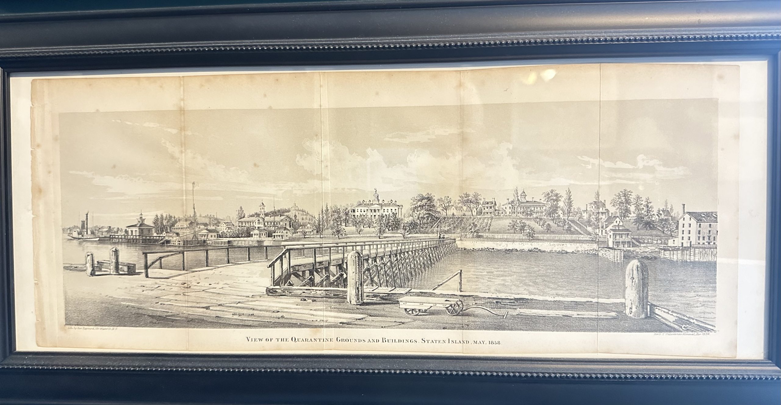
Five acres of this property (lower right corner on the image) was purchased from New York State by United States Government to establish facilities for the U.S. Revenue Cutter Service in cooperation with the Quarantine. The insert in the lower right is an early image of the Administration Building of the U.S. Lighthouse Service erected in 1869 shortly after the government property was transferred from the Revenue Cutter Service to the Lighthouse Service. The building, as well as other historic and landmarked buildings, still stand on the former government property (the Coast Guard was also stationed here when it merged with the Lighthouse Service). The current National Lighthouse Museum is located in the smallest of these historic buildings.
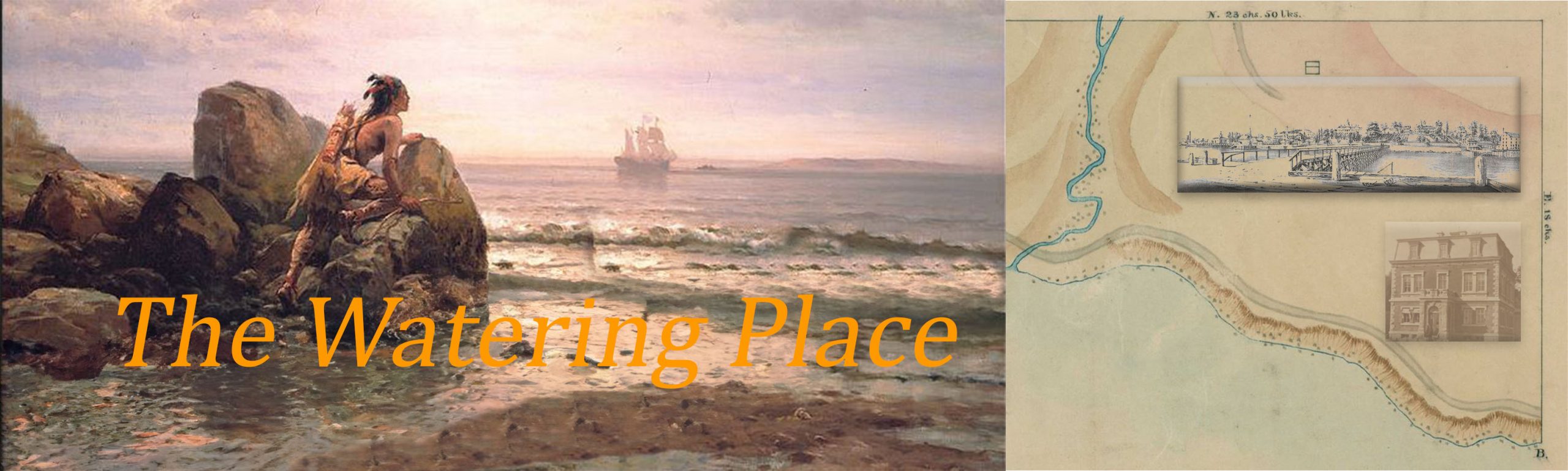
The 25 acres of the New York State property served as the Quarantine grounds that operated from 1799 to 1858 until Staten Island residents burned all the buildings down in what the Staten Island papers came to call “The Quarantine Wars”. The upper inset in the right panel is a lithograph entitled ‘View of the Quarantine Grounds and Building, Staten Island, May 1858” engraved by George Hayward and issued in the 1859 edition of D.T. Valentine’s Manual. Several online sources confuse some of these buildings with the US Lighthouse Service buildings that are still standing on the former US government property and with the Seamans Retreat property on the former U.S. Marine Hospital on the Bayley-Seton campus south of the quarantine ground area. All of the buildings represented in this image have been obliterated.
from Valentine, D.T. (1859) Manual of the Corporation of the City of New York, 1859, NYC Municipal Library. Author’s personal collection
Office Building of the U.S. Lighthouse Service Depot 1884. Construction began in 1869
and was completed in 1870 when the 2nd floor and roof were added. National Archives.
************************
There are some connections to the Seton Hall story too. A lot of what is known about the Lenape Indians comes from the work of the late Seton Hall professor Herbert Kraft. When the Quarantine Grounds opened in 1799 the first health officer was Dr. Richard Bayley. He was a well-respected physician, professor of anatomy and surgery, and humanitarian who played a significant role in the early approaches to quarantine and in gaining a better understanding of infectious disease. He was also the father of Elizabeth Ann Bayley Seton and the grandfather of Seton Hall’s founder, Bishop James Bayley.
This project blog site will tell the story of the many historical events that took place at the Watering Place. But the project is not just about history. The Quarantine story, for example, provides insight into scientific thinking (e.g., how ideas about disease changed). Interestingly, the Staten Island Quarantine is also directly connected to the birth of federally-funded biomedical research. The National Institutes of Health (NIH) was born on Staten Island in a nearby federal facility when a scientist was hired to establish a laboratory to find a way to reliably diagnose cholera. The laboratory was successful and it was moved to Washington DC.
Additional content on historical men and women associated with the Watering Place will be added to this project gradually. Explore the names below for a preview:
Michael Vigorito, PhD
Department of Psychology
Seton Hall University