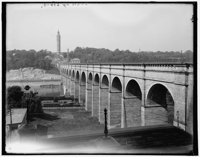
The High Bridge is the oldest standing bridge in New York City. It spans over the Harlem River at 173rd Street in Manhattan. [1] The Roman styles bridge was constructed in 11 years. It served as a conduit for the Croton Aqueduct System. The High Bridge Water Tower along with the bridge are considered state landmarks. [2] Today the High Bridge no longer is a conduit but used a connection between Manhattan and The Bronx. In 2015, the pedestrian walkway was reopened to the public. New York City’s parks commissioner, Mitchell Silver, states in an interview with Lisa Foderaro for New York Times as a “place to connect with the generations of creativity, determination and genius who built our city.” [3]
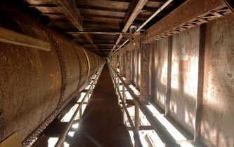
Iron Pipes [2]The High Bridge was completed in 1848 as a part of the Croton Aqueduct System. The aqueduct system was built to simply bring in pure water from Westchester County. During the late 1800s, the necessity of clean water increased. The city’s water before the aqueduct system was so polluted that it was leading to diseases. The aqueduct started from the head of the Croton River and passed along into the Hudson valley. The aqueduct ran for 8 miles before reaching Sing Sing, then continued south through Tarrytown, Hastings, Yonkers then finally reaching the city of New York. [4] The length from the Croton River to Harlem River was 32.88 miles. [5] The Croton Aqueduct system was built before the Highline Bridge. During the construction of the aqueduct, the Highline Bridge was built above the Harlem River to convey the water through iron pipes into the city. [6] The aqueduct system continued for nearly another 2 miles to reach the two reservoirs in Manhattan. The total length of the aqueduct from the Croton River to the distributing reservoir was 40 miles.
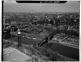
Aerial View of High Bridge and Highbridge Park, 1978 [3]Once known as the Harlem River Bridge, High Bridge connects The Bronx to Manhattan through the Croton Aqueduct system. John B. Jervis was the lead engineer in the construction of the bridge. He designed the bridge to be elevated and with angle from one side in order for the water to move due to gravity. [7] Jervis also designed the bridge to conceal the pipes from the Croton Aqueduct system within the bridge. His general plan for the bridge is stated in his Description of the Croton Aqueduct, written in 1842. He states that the bridge was planned to have 14 total semicircular arches and two abutments that terminate the arches. The length of the bridge is 1450 feet with a height above the high water line of 60 feet. [8] Jervis designed to have parapets (safety barriers) that would protect two cast iron pipes. Since the Croton Aqueduct system was a free flow of water, the pipes were made to secure the conduit from water leakage. Gate chambers were also added to both ends of the bridge to regulate the water. The north gate chamber (the chamber on the Manhattan side) was important because it had a waste weir in order to discharge surplus water. [9] By the 1870s, the city government attained more land on higher ground above the High Bridge where a reservoir and water tower was built on the ground. The tower was built in 1872 to increase water pressure for the increasing demand of water in the city. John Jervis carefully built the tower to conceal the water tank, just like how the aqueduct pipes are concealed in the bridge. [10] The design of the bridge was carefully planned by John Jervis to supply clean water to the city. The High Bridge later will serve the people of New York in a different way.
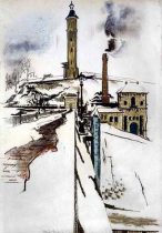
“Water Tower at High Bridge” by Preston Dickinson, 1922 [4]Postcard [5]By 1864, the pedestrian walkway was completed, making the bridge a famous attraction to not only New Yorkers but to tourists. [11] For artists and photographers, the bridge became a beloved subject. It was also a bridge that Edgar Allen Poe liked to walk on. The sudden popularity of the bridge led to new attractions in the area such as restaurants and amusement parks. The High Bridge also gave The Bronx a chance to have more visitors and boats that would now cruise up and down the Harlem River. This led to racing competitions in 1898 on the river known as Harlem River Speedway. In an article written in The New York Times on June 7, 1885, it was stated that there are not pleasant places of amusement by the bridge. [12] The article states “there are not a few charming places of amusement at High Bridge.” [13] The Bronx at that time was not a place New Yorkers would visit. Although the bridge led to a new attraction, the Bronx was still criticized. Shortly after the completion of the walkway, there was a proposal to build a park. According to an article named No High Bridge Park At Present in the New York Times, the park’s land was to be set aside by Judge Barrett. [14] The Park Commissioners were allowed to mark out the boundaries of the park but cannot acquire the land [15]. The land for the park was held in court for a few years before there was an official decision to build the park. New York Times published an article in 1889 explaining that the original plan of the park’s area was going to be reduced. [16] The park was finally approved and the city purchased the land to create Highbridge Park in the 1890s. [17] The natural cliffs and large rock ledges made the park a destination to remember for New Yorkers. In 1914, Fort George’s amusement park was ruined by a fire and the city purchased the grounds to make the park bigger [18]. By the 1920s, Highbridge Park was Manhattan’s second largest park. [19] The High Bridge became a hot spot for tourist because the park. However during the mid-1920s there was a proposal to remove the entire bridge because it was a hazard to navigation. After many protests to preserve the bridge, five of the bridges’ arches had to be replaced with a single steel arch. The High Bridge’s popularity slowly decreased as other attractions were seen as more fun. Unfortunately after the construction of the Major Deegan Expressway in 1956 and the Harlem River Drive in 1964, which runs directly underneath both sides of the bridge, public use and aqueduct use of the bridge faded completely. [20] The river became polluted and public access to the bridge was discontinued in the 1960s.
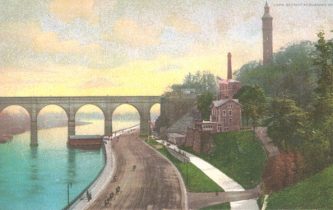
Bronze Medallion [6]Eventually groups such as The High Bridge Coalition led citizen campaigns to restore the bridge and its parks. Luckily, former Mayor Michael Bloomberg in 2007 proposed the revival and restoration of eight parks and sites in the city and the High Bridge was one of them. In June of 2015, after an expense of $61.8 million, the bridge’s walkway finally opened after almost six decades of being closed. [21] The restoration was financed by the Federal Highway Administration. The bridges’ restoration included re-mortaring stone joints, restoring the original handrails, repainting the steel arch and adding lighting and a safety fence. The walkway now has bronze medallions that are embedded with the bridges’ history. It now serves its purpose again to bring together Manhattan and The Bronx.
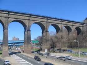
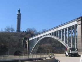
High Bridge over the Major Deegan Expressway [7]High Bridge over Harlem River [8]High Bridge is the oldest surviving bridge in New York City. It is a New York City landmark because it was a part of the Old Croton Aqueduct system. The significance of the High Bridge may no longer be to serve as a conduit but it still brings two boroughs together.
Images:
[1] Foderaro, Lisa W. High Bridge Reopens After More Than 40 Years. New York: The New York Times, 2015.
[2] “History of the High Bridge” High Bridge: NYC Parks, NYC Parks
Jackson, Kenneth T., and Society New-York Historical. 2010. The Encyclopedia of New York City. New Haven: Yale University Press, 2010. eBook Academic Collection (EBSCOhost), EBSCOhost.https://eds.a.ebscohost.com/eds/ebookviewer/ebook/ZTAwMHhuYV9fNTY4MjQ5X19BTg2?sid=7cc70149-7812-45e3-ba1b-c02760e5438b@sessionmgr4010&vid=3&format=EB&rid=10
Jervis, John B. Description of the Croton Aqueduct. New York: Slamm and Guion, 1842. 5-31
NO HIGH BRIDGE PARK AT PRESENT. (1886, Mar 09). New York Times (1857-1922)Retrieved from https://search.proquest.com/docview/94396461?accountid=13793
SOLL, DAVID. Empire of Water: An Environmental and Political History of the New York City Water Supply. Ithaca; London: Cornell University Press, 2013. https://www.jstor.org/stable/10.7591/j.ctt1xx649.